
Property Analyser · by The Owlery Works
Know what the listing
leaves out.
Any NSW address: school zones, transport, crime, flood and bushfire risk, rents and past sales. Plus a diary for every inspection.
Finishing final touches. Not on the App Store yet — the download link appears here the day it is.
What you get
One address, everything public about it.
-
Schools
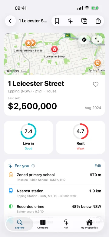
The schools the address is zoned for, and every school nearby.
-
Getting around
Stations, buses, shops, parks and GPs close by.
-
Safety and risk
Crime against the NSW average, zoning, and flood and bushfire maps.
-
Sales and rents
Past sale prices, local medians and rents nearby.
-
Scores and priorities
Out of 10 for living and renting there, with what matters to you shown first.
-
Compare and ask
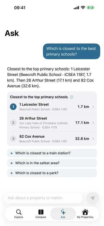
Put three homes side by side, or ask which one is closest to a station.
Inspection diary
Remember every home you walk through.
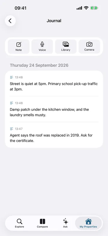
Notes, voice memos, photos and video for each home you inspect. Voice memos become text on your phone. The diary never reaches us, and iCloud sync can take it to your iPad.
The notes in the picture were typed for it.
On an iPhone
See it working.
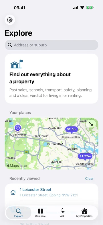
Real screens from the app. The saved homes were added for the pictures.
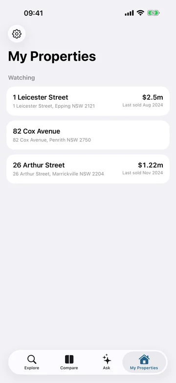
Scroll sideways for all four.
On an iPad
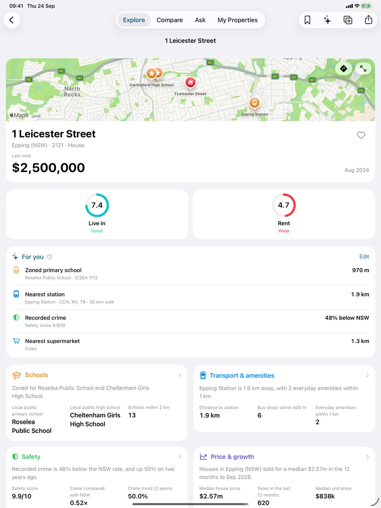
The whole picture on one screen.
Schools, transport, safety and sales, side by side.
Free, and private
Your searches aren’t kept.
Free, with no ads and no account. Lookups use our server, which answers and keeps no record. Your homes and diary never reach us.
| Devices | iPhone and iPad, iOS 26 or later. |
|---|---|
| Ask | Needs Apple Intelligence. Everything else works without it. |
| Internet | Needed for lookups. Your diary works offline. |
Where the data comes from
Public data, with credit where it is due.
Government agencies and OpenStreetMap publish the data. The app shows the source of every figure. A guide, not financial advice.
All 17 sources, what they are used for, and their licences
- Addresses. Finding the address you search for, placing it on the map, and measuring its distance to the Sydney CBD.
Geocoded National Address File (G‑NAF), Geoscape Australia. Licence: G‑NAF Open End User Licence Agreement.Incorporates or developed using G-NAF © Geoscape Australia licensed by the Commonwealth of Australia under the Open Geo-coded National Address File (G-NAF) End User Licence Agreement.
- Suburbs and areas. Working out which suburb and statistical area an address is in.
Australian Statistical Geography Standard (ASGS), Australian Bureau of Statistics. Licence: CC BY 4.0.Source: Australian Bureau of Statistics, Australian Statistical Geography Standard.
- Who lives nearby. Who lives in the area: ages, household incomes, owners and renters, and rents against incomes.
Census of Population and Housing, Australian Bureau of Statistics. Licence: CC BY 4.0.Source: Australian Bureau of Statistics, Census of Population and Housing.
- Advantage. The area's socio-economic decile, which is one part of the Live in verdict.
Socio-Economic Indexes for Areas (SEIFA), Australian Bureau of Statistics. Licence: CC BY 4.0.Source: Australian Bureau of Statistics, Socio-Economic Indexes for Areas.
- New homes. How many new dwellings have been approved in the area.
Building Approvals, Australia, Australian Bureau of Statistics. Licence: CC BY 4.0.Source: Australian Bureau of Statistics, Building Approvals, Australia.
- Sales. Each recorded sale of a property, and the suburb's median house and unit prices and number of sales over the last twelve months.
NSW Property Sales Information, NSW Valuer General. Licence: CC BY-NC-ND 4.0.Contains property sales information provided under licence from the Valuer General NSW.
- Rents. What homes nearby rent for, how rents have changed, and the estimated weekly rent.
Rental Bond Lodgements, NSW Fair Trading. Licence: CC BY 4.0.Source: NSW Fair Trading rental bond data.
- Crime. Recorded crime in the suburb against the NSW rate, its two-year trend, and the safety score.
Recorded Criminal Incidents by Suburb, NSW Bureau of Crime Statistics and Research. Licence: CC BY 4.0.Source: NSW Bureau of Crime Statistics and Research.
- Zoning. The planning zone, height and floor-space limits, minimum lot size and heritage listing.
NSW Principal Planning Layers, NSW Department of Planning, Housing and Infrastructure. Licence: CC BY 4.0.Contains planning data © State of New South Wales (Department of Planning, Housing and Infrastructure).
- Bushfire. Whether the land is mapped as bushfire‑prone.
NSW Bush Fire Prone Land, NSW Rural Fire Service. Licence: CC BY 4.0.Contains Bush Fire Prone Land data © State of New South Wales (NSW Rural Fire Service).
- Flood. Whether the land is in a mapped flood planning area. Councils map this, and not all have: an address outside the map is not necessarily free of flood risk.
NSW Flood Planning Areas, NSW Government. Licence: CC BY 4.0.Contains flood planning data © State of New South Wales.
- Catchments. Which government primary and high school the address is zoned for.
NSW Government School Intake Zones, NSW Department of Education. Licence: CC BY 4.0.Source: NSW Department of Education.
- Government schools. Government schools near the address, and their ICSEA.
NSW Public Schools Master Dataset, NSW Department of Education. Licence: CC BY 4.0.Source: NSW Department of Education.
- Other schools. Non-government schools near the address, and each school's ICSEA percentile.
School Profile and School Location, Australian Curriculum, Assessment and Reporting Authority. Licence: My School Terms of Use.Source: Australian Curriculum, Assessment and Reporting Authority (ACARA).
- Childcare. Approved day care, preschools and after-school care near the address.
National Registers of Approved Education and Care Services, Australian Children's Education and Care Quality Authority. Licence: ACECQA Terms of Use.Source: Australian Children's Education and Care Quality Authority (ACECQA).
- Transport. Stations and the lines they serve, bus stops and services, and walking distances to them.
Timetables Complete GTFS, Transport for NSW. Licence: CC BY 4.0.Source: Transport for NSW.
- Everyday places. Supermarkets, parks, GPs and other everyday places nearby.
OpenStreetMap, OpenStreetMap contributors. Licence: ODbL 1.0.© OpenStreetMap contributors.
Something not working?
Raise a case with or without an email address.